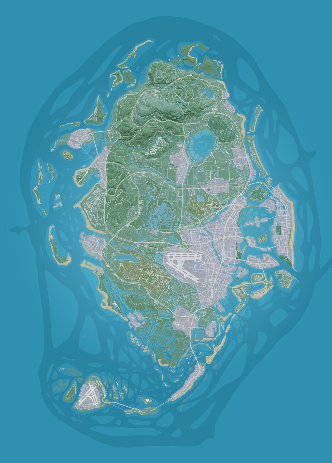
The Leonida counties in GTA 6 are Vice-Dale, Mariana, Leonard, Kelly and Lummox. Rockstar named all five on the printable state map it released with the game on 19 November 2026. Before launch, players only knew Leonida by six marketing areas (Vice City, the Leonida Keys, Grassrivers, Port Gellhorn, Ambrosia and Mount Kalaga National Park), so most people have never heard the county names.
Searches for Leonida counties GTA 6 mostly want the same three things: the five names, where each county sits on the map, and which towns belong to it. All three are on this page — the table gives the names and positions, and each county below has its own section.
Each of the Leonida counties is bigger than those six areas. Vice City is one part of Vice-Dale County, and the Grassrivers run through Mariana County. Every place named on this page is on our interactive Leonida map — type its name into the search box and the map jumps to it.
The five Leonida counties in GTA 6 at a glance
| County | Where it sits | Neighbouring counties | One standout place |
|---|---|---|---|
| Vice-Dale County | South-east coast | Mariana, Leonard | Vice City and Vice Beach |
| Mariana County | South and south-west | Vice-Dale, Kelly | Mile Zero Air Station |
| Leonard County | Centre and east | Vice-Dale, Kelly, Lummox | Lake Leonida |
| Kelly County | West and north-west | Mariana, Leonard, Lummox | Port Gellhorn |
| Lummox County | Northern border | Kelly, Leonard | Mount Kalaga |
The county positions and neighbours come from the places community mappers have tagged with each county in the GTADB database, not from a county list published by Rockstar. Rockstar's printable map draws the county lines but does not say which towns fall inside each one.
How the Leonida counties are laid out in GTA 6
Think of the state as five slices. Lummox caps the top of the map. Below it, Kelly takes the west and Leonard the middle and east. At the bottom, Mariana covers the south-west swamps and keys, and Vice-Dale holds the south-east corner with the big city.
The tagged places give a rough sense of where each county starts and ends. Lummox places sit north of about Y 5,600 in game coordinates (the numbers shown on every place card on our map). Kelly places run from the Gulf coast at X −9,200 inland to about X −3,000. Leonard places sit between Y 1,500 and Y 5,300 around the lake. Mariana places run from about Y −450 down to about Y −7,900 at the bottom of the map. Vice-Dale places stay close to the Atlantic, east of about X −2,800.
Vice-Dale County on the GTA 6 Leonida map
Where it is. Vice-Dale is the south-east corner of the state, along the Atlantic coast. Leonard County lies to its north, and Mariana County wraps around its south-western edge where the city gives way to swamp. It is the most built-up of the Leonida counties.
What you can find there. Vice-Dale is the busiest of the Leonida counties: it holds Vice City and the barrier island of Vice Beach, which together carry 394 named places, far more than any other county. The county's own label sits on the landmarks around the city — the golf club on Leaf Links, the sea port on Watson Island, the Coast Guard base and the Star Island Bridge — and offshore the seabed holds a couple of dive sites.
Real-world inspiration. The name points to Miami-Dade, and Vice City is Rockstar's Miami. Building-by-building matches are on the real-life locations page.
Mariana County on the GTA 6 Leonida map
Where it is. Mariana covers the south and south-west of the state: the wetlands below Vice City, the Gulf coast down from Watson Bay and the long chain of keys that runs out to sea. Vice-Dale borders it to the north-east and Kelly County to the north-west. Its tagged places spread wider than any other county's: about 7,400 units east to west and the same north to south.
What you can find there. Mariana is the widest and wildest of the Leonida counties: wetlands in the north, a long Gulf coast and the keys that run out to sea. The Grassrivers fill the top of the county, and the Leonida Keys — where Jason's story begins — start at Key Lento (31 named places) and run down to the shoals at the bottom of the map. An airfield, an underwater research station and an RV park sit between them.
Real-world inspiration. The Everglades and the Florida Keys; the air station is matched to Naval Air Station Key West.
Leonard County on the GTA 6 Leonida map
Where it is. Leonard is the middle of the state, built around the big lake. Vice-Dale lies to its south, Kelly to its west and Lummox to its north. Its tagged places reach east to Sharktooth Island and the Leith River.
What you can find there. Leonard is the farmland county: Lake Leonida fills its centre, a canal runs east from the lake, and the small town of Belville sits on its shore with the Leonard County Sheriff's Office. The county's eastern edge reaches Sharktooth Island and the Leith River, and there is an airfield, a farm and a water tower in between.
Real-world inspiration. Lake Leonida is matched to Lake Okeechobee, and Belville's sheriff's office to one in Immokalee.
Kelly County on the GTA 6 Leonida map
Where it is. Kelly fills the west and north-west of the state along the Gulf coast, from Wild Hog Point and Borrachero Sound in the west to the hills east of Route 628. Mariana lies to its south, Leonard to its east and Lummox to its north. From east to west it is the second-widest of the Leonida counties, after Mariana.
What you can find there. Kelly is the west-coast county with its own city: Port Gellhorn, with 73 named places and another 61 around the Gellhorn International Raceway. Inland, the county is hills and scrub either side of Historic Route 628, with a mud club, a tower and a canyon, plus a prison and the Crude Islands offshore.
Real-world inspiration. Mostly the Florida Panhandle: many Port Gellhorn shops are matched to Panama City.
Lummox County on the GTA 6 Leonida map
Where it is. Lummox runs along the northern border, the top edge of the state, above Kelly and Leonard. Its coast faces San Malo Bay in the west and Partridge Bay and Okchiloha Bay in the north. It is the most rural and hilly of the Leonida counties.
What you can find there. Lummox is the emptiest of the Leonida counties: most of it is Mount Kalaga National Park, with the state's highest ground, a reservoir and dam, an airfield and old rail tunnels. The northern coast has a lighthouse and a small island chain, and the county's one town, Millport, holds the only port and train station this far north.
Real-world inspiration. Rockstar borrowed from outside Florida here: Mount Kalaga is matched to Table Rock Mountain and Dawson Dam to Tallulah Falls Dam in Georgia.
Leonida counties in GTA 6: towns with no county label yet
Some towns have no county tag in the community data yet. They include Ambrosia (the sugar town with the Allied Crystal mill), Hamlet (57 named places on the edge of the Grassrivers), Capri, Watson Bay and Waning Sands. Going by their coordinates, Ambrosia (X −2,764, Y 3,900) and Waning Sands (X −71, Y 4,093) sit inside the area of Leonard County's tagged places, and Hamlet (Y −3,075) and Watson Bay (Y −3,086) inside Mariana's. That is our reading of the data, not a confirmed county. We will add them to the Leonida counties table once it is, and their real-life matches are already on the Leonida real-life locations page.